


Nguyen Dinh Ngoc Hai (Clint, Mr), Eng
Electrical Engineer - VATEC
May 31, 2023
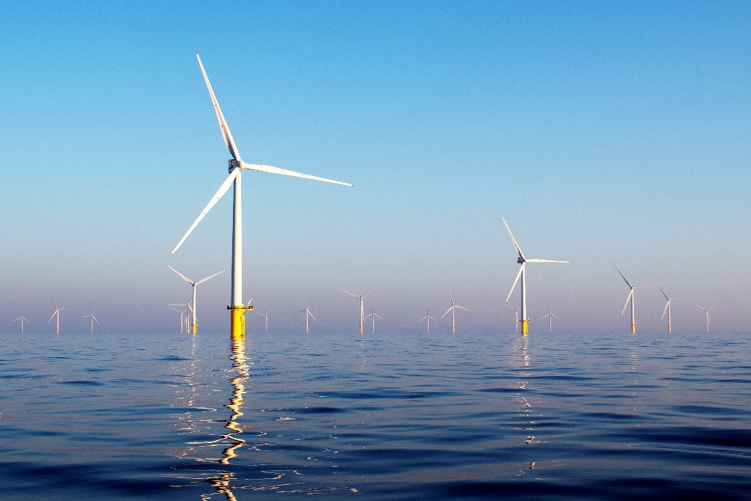
Trong quá trình nghiên cứu và phát triển các dự án điện gió thì công tác khảo sát đo gió là hết sức quan trọng, nhằm đánh giá tính khả thi của dự án đầu tư thông qua tiềm năng gió tại vị trí dự án.
Việc thực hiện khảo sát đo gió là bắt buộc trước khi lập và phê duyệt báo cáo nghiên cứu khả thi của dự án điện gió, với thời gian đo tối thiểu là 12 tháng liên tục tại các vị trí có tính đại diện trong khu vực dự án. Căn cứ pháp lý về địa điểm đo gió được quy định cụ thể tại Điều 5, Thông tư số 02/2019/TT-BCT ngày 15/1/2019 của Bộ Công Thương. Việc lựa chọn phương án, thiết bị và vị trí đo gió phải đáp ứng theo quy định pháp luật của Việt Nam cũng như các tiêu chuẩn IEC có liên quan.
Các công nghệ thu thập dữ liệu gió hiện đang được sử dụng phổ biến nhất trên toàn thế giới gồm có: Phương pháp sử dụng cột đo gió, phương pháp sử dụng công nghệ SODAR và phương pháp sử dụng công nghệ LIDAR.
I. Phương pháp sử dụng cột đo gió
Đây là phương pháp khảo sát gió truyền thống và được sử dụng rộng rãi nhờ độ chính xác cao. Các loại cảm biến được gắn trên cột đo gió để thu thập các số liệu như: tốc độ gió, hướng gió, nhiệt độ, độ ẩm, áp suất, bức xạ mặt trời,…

Cho đến nay, việc khảo sát gió cho các nhà máy điện gió dựa vào cột đo gió làm tiêu chuẩn. Chiều cao của cột đo gió hiện tại phổ biến là ≥ 100m, tương ứng với chiều cao của tuabin gió dự kiến sử dụng cho dự án và phải được đặt ở vị trí mà luồng không khí đi qua địa điểm khảo sát không bị cản trở bởi các chướng ngại vật hoặc các đặc điểm địa hình làm sai lệch luồng không khí. Cột đo gió được lắp dựng trên mặt đất, tất cả các cảm biến và thiết bị liên quan được kiểm tra kỹ càng trước khi bắt đầu lắp ráp lên cột.

Tuy nhiên, để triển khai lắp dựng cột đo gió sẽ cần một khoảng không gian nhất định để bố trí móng chính và các vị trí móng neo, do đó sẽ tương đối khó khăn khi triển khai khảo sát gió tại vùng đồi núi hiểm trở hoặc vùng biển ngoài khơi,…
II. Phương pháp sử dụng công nghệ SODAR
Nguyên lý hoạt động của công nghệ đo gió SODAR:
SODAR (tên đầy đủ là: Sound Detection And Ranging) là một công cụ khí tượng được sử dụng như một máy đo gió dựa trên sự tán xạ của sóng âm do nhiễu loạn khí quyển. SODAR bao gồm 03 chùm tia trở lên ở các góc khác nhau so với phương thẳng đứng cho phép thu được mặt cắt gió thẳng đứng ba chiều. Cả cường độ và độ dịch chuyển Doppler của phản hồi đều có thể được sử dụng để xác định tốc độ và hướng gió cũng như cấu trúc hỗn loạn của tầng khí quyển thấp hơn, lên tới khoảng 2 km (tùy thuộc vào công suất đầu ra của hệ thống, tần số âm thanh, độ ổn định của khí quyển, nhiễu loạn và môi trường tiếng ồn hiện có).

Nguyên lý hoạt động của thiết bị SODAR
Cấu trúc liên kết điển hình nhất là SODAR “đơn-tĩnh”, trong đó máy phát và máy thu đều được lắp đặt tích hợp trong một cấu hình tương đối nhỏ gọn. Ngoài ra, hầu hết các hệ thống SODAR hiện nay trên thị trường là hệ thống SODAR Doppler đa trục, có nghĩa là chúng có khả năng phát hiện sự thay đổi tần số tín hiệu theo 03 hướng trở lên và sử dụng dữ liệu đó để thu được cấu hình của tốc độ gió và hướng gió theo phương thẳng đứng. Thành phần cơ bản nhất của hệ thống SODAR Doppler là ăng ten và đây là bộ phận mà các hệ thống SODAR thương mại của các nhà sản xuất khác nhau nhiều nhất.

Thiết bị đo gió bằng công nghệ SODAR của hãng AQ System

Trạm Sodar AQ500 SoDAR
Ưu điểm:
- Nhỏ gọn, dễ dàng triển khai ở mọi địa hình, độ an toàn cao nên cũng sẽ tránh được nhiều vấn đề về trách nhiệm pháp lý.
- Có sẵn trên thị trường.
- Tính di động cao.
- Chi phí lắp đặt và chi phí vận hành thấp, không yêu cầu bảo trì thường xuyên.
- Hoạt động ngay cả dưới thời tiết khắc nghiệt, không bị ảnh hưởng bởi sương mù.
- Phạm vi lên tới 2km, trong đó dải cao độ có độ phân giải tốt là 10-100m.
III. Phương pháp sử dụng công nghệ LiDAR

Trạm đo gió LiDAR điển hình
Nguyên lý hoạt động của công nghệ đo gió LiDAR:
LiDAR (tên đầy đủ là: Light Detection and Ranging) là một công nghệ viễn thám quang học, thực hiện bằng cách phát ra chùm tia laser vào không khí, các chùm tia này va chạm vào các hạt và sol khí, sau đó phản xạ ngược lại, bằng cách thu lại và phân tích các chùm tia phản xạ, thiết bị có thể tính toán ra được các thông số về tốc độ gió và hướng gió ở các độ cao khác nhau. Công nghệ này có thể triển khai ở cả mặt đất, trên biển và trên không (lắp đặt trên các tuabin gió), tùy thuộc vào các ứng dụng khác nhau.

Nguồn: Leosphere
LiDAR có thể sử dụng bức xạ trong vùng tử ngoại, vùng ánh sáng nhìn thấy và vùng hồng ngoại của quang phổ điện từ, và mỗi vùng sẽ có những tương tác khác nhau với khí quyển. Do đó, việc lựa chọn quá trình tán xạ khác nhau cho phép suy ra một loạt các thông số về luồng không khí, chẳng hạn như thành phần không khí và gió. Sự phân kỳ nhỏ của chùm tia laser dẫn đến độ rộng chùm tia rất thấp, cho phép độ phân giải cao ngay cả ở những độ cao hàng trăm mét.
Phân loại hệ thống đo gió LiDAR:
- LiDAR xung: Một chùm tia laser có bước sóng 1,54 μm thực hiện phép đo tốc độ gió theo hướng chùm tia laser. Để thu được vector gió ba chiều, chùm tia nghiêng 30 độ so với phương thẳng đứng và các phép đo được thực hiện dưới 04 góc phương vị khác nhau.

Nguồn: Leosphere
- LiDAR phát ra chùm tia ánh sáng liên tục (CW): một cách tiếp cận khác đó là FMCW LiDAR (hay còn gọi là LiDAR phát sóng liên tục được điều chế tần số), thay vì gửi các xung theo thời gian, FMCW LiDAR gửi một luồng ánh sáng laser liên tục (sóng liên tục) và thay đổi tần số của nó theo các khoảng thời gian đều đặn (điều chế tần số). Điều này cho phép xác định cả vị trí của các đối tượng và đo chính xác tốc độ tương đối dọc trục của chúng bằng hiệu ứng Doppler.

Nguyên lý hoạt động của FMCW LiDAR
Ưu điểm:
- Công nghệ đã xuất hiện từ lâu, dữ liệu thu thập đáng tin cậy.
- Đã được triển khai rộng rãi trên toàn thế giới.
- Hầu hết các hãng sản xuất phao nổi (Lidar Buoy) trên thế giới đều sử dụng công nghệ Lidar.
- Cần ít không gian hơn so với cột đo gió truyền thống; có tính di động cao.
- Hoạt động ngay cả dưới thời tiết khắc nghiệt.
- Chi phí lắp đặt và chi phí vận hành thấp, không yêu cầu bảo trì thường xuyên.
- Có thể đo được ở độ cao lên đến 300m.
- Kích thước nhỏ gọn, dễ triển khai và độ an toàn cao nên cũng sẽ tránh được nhiều vấn đề về trách nhiệm pháp lý.
Kết luận: Năng lượng tái tạo nói chung và năng lượng gió nói riêng đang được xem là giải pháp và xu hướng tất yếu của ngành năng lượng hiện nay ở Việt Nam cũng như trên thế giới. Khi các nguồn nhiên liệu hóa thạch như than đá, dầu mỏ ngày càng trở nên cạn kiệt, gây ô nhiễm môi trường nghiêm trọng, buộc các Quốc gia trên thế giới phải đẩy mạnh chuyển dịch cơ cấu ngành năng lượng theo hướng sạch và bền vững, mở ra cơ hội to lớn cho ngành công nghiệp điện gió phát triển. Cùng với sự tiến bộ không ngừng của khoa học – kỹ thuật, các công nghệ đo gió ngày càng phát triển và được ứng dụng rất hiệu quả trong lĩnh vực khảo sát, quan trắc, đánh giá tiềm năng gió, phục vụ công tác phát triển, đầu tư các dự án điện gió sau này.
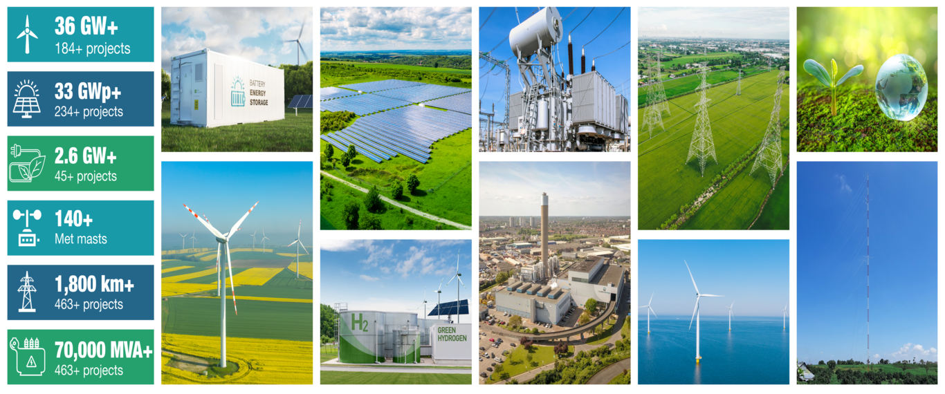
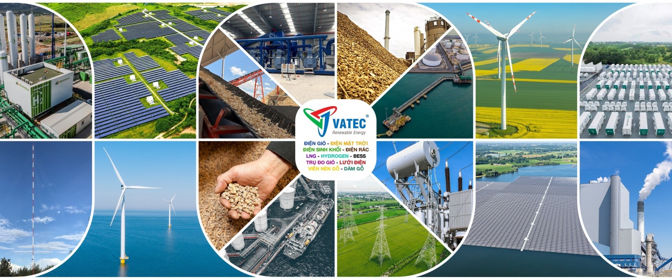
Công ty TNHH Tư vấn Năng lượng VATEC tự hào là đơn vị hàng đầu trong lĩnh vực đo gió tại Việt Nam, với kinh nghiệm xây lắp hơn 120 trụ đo gió cao đến 140m và trạm đo gió Lidar cho nhiều dự án điện gió trên cả nước.
Tài liệu tham khảo:
[1] Steven Lang, Eamon McKeogh, “LIDAR and SODAR Measurements of Wind Speed and Direction in Upland Terrain for Wind Energy Purposes”, Remote Sensing, 25 August 2011.
[2] Leosphere, “WINDCUBE USER GUIDE”, August 2019.
[3] Outsight, Dec 22, 2022, “How does Lidar work?”. Online available: https://www2.outsight.ai/insights/how-does-lidar-work
[4] https://vatec.vn/
Copyright © all rights reserved


